Today, Provincetown, Massachusetts is largely regarded as being a prime vacation destination, known for its beautiful beaches, bustling town center, and LGBT friendliness. Located on the outermost tip of Cape Cod, Provincetown is surrounded on three sides by water, bordered to the east only by Truro. The town consists of two main streets running from west to east, on which most of the economic activity occurs. Its hectic center and picturesque dunes attract all kinds of visitors, from renowned artists to wealthy vacationers. Provincetown is also regarded as being “America’s Gayest City,” and drag shows and other similar events are frequently advertised.1 There is something for everyone in this bustling seaside resort town.
Provincetown’s history extends as far back as that of the country: its sandy seascape was the first land that the Pilgrims reached on their voyage aboard the Mayflower.2 Since then, Provincetown has evolved from a small fishing village that was barely on the map to one of the more popular tourist destinations on the New England coast. But how did this happen? What caused Provincetown to turn into a popular vacation destination, distinctly known for its art and liberalism, instead of decaying into an irrelevant coastal town like so many other places? To answer this question, we must look to Provincetown’s natural and historical landscapes, and examine how they interacted over time to create a unique coastal vacation destination with a particular affinity for the arts and LGBT culture.
In its early days, Provincetown’s livelihood was largely shaped around its physical geography. Located on the tip of Massachusetts’ Cape Cod Peninsula, Provincetown was very isolated and difficult to access.
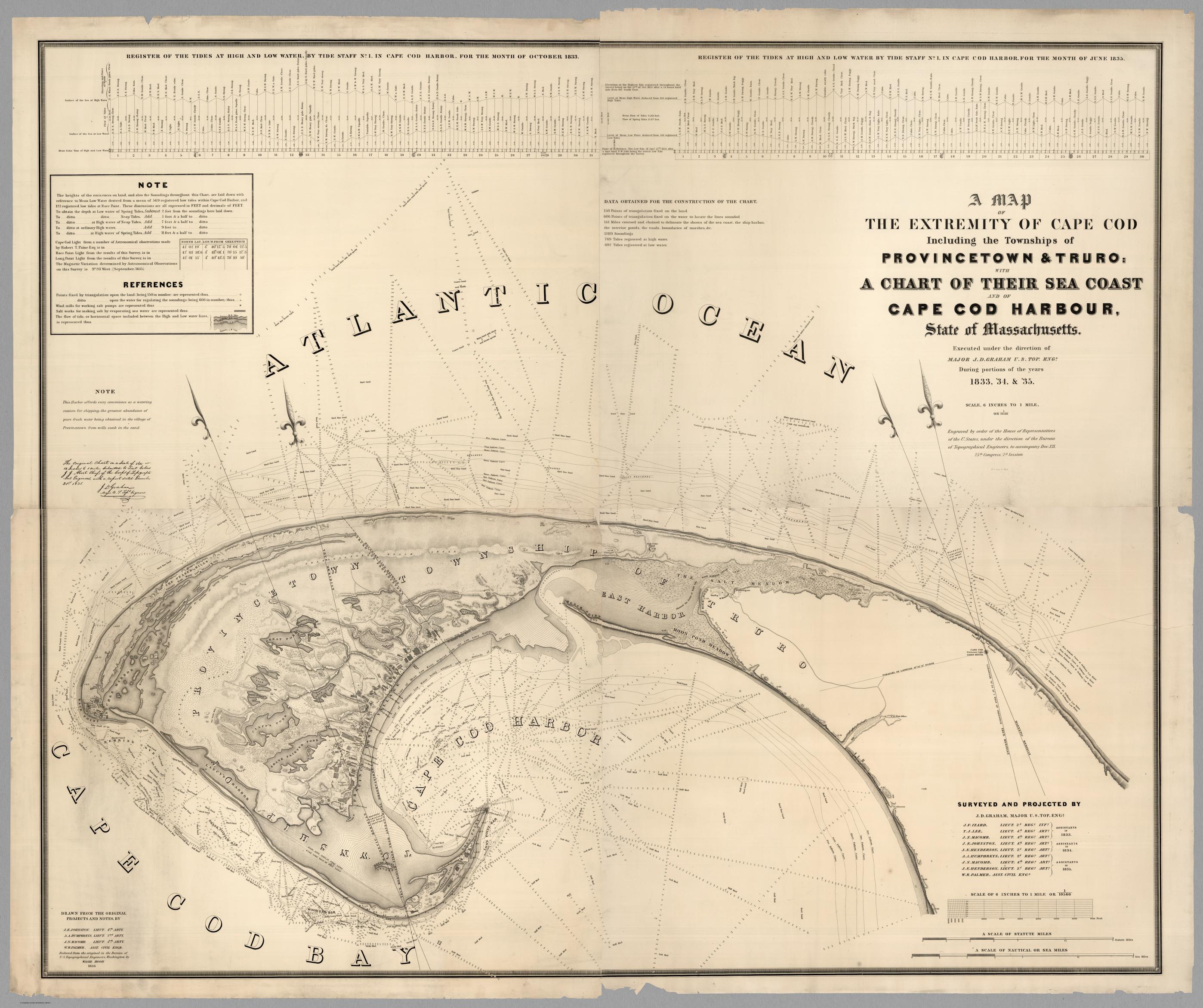
As seen in the map above, up until the middle of the 19th century, the only way to access the town was by a narrow strip of land on the northern side of East Harbor. This strip consisted of sandy dunes and was difficult to traverse.3 This meant that those who lived in Provincetown were forced to rely primarily on the resources available to them locally - namely the ocean and its amenities. The curvature of the peninsula creates a sheltered bay to the south of the town, and the open ocean lies to the north, creating two distinct ocean environments from which Provincetown residents can benefit. Residents participated in a variety of industries that utilized these environments, including whaling, fishing, salt manufacturing, trading, and smuggling.4 These industries allowed Provincetown’s economy to boom, up until their decline in the early 20th century.
In order to examine the rise and fall of the fishing and whaling industries, we can look to the fishing wharves that remain along the bay side of the town. MacMillan Wharf is the most prominent wharf of the few that remain today, but in the town’s heyday around the 1860s, there were upwards of 50 wharves in use.5 As the name of the region suggests, cod fish were one of the main types of fish caught and sold. These fish were often laid out on the wharves to dry, covering nearly every surface available.

A newspaper article pasted in a scrapbook belonging to Althea Boxell describes what the town looked like during the height of the fishing season in the mid 1800s: “the sight of the town must have been amazing-the entire length and breadth of the place being overspread with cod, even the front yards and spaces between the dwellings.”6 This surplus in fish allowed for a boom in the fishing economy in the mid to late nineteenth century, which led the town to reach its peak population of 4,642 residents in 1890.7 Provincetown was only able to become a successful fishing village because its residents utilized the landscape. The geography of the area did not allow for the creation of a large city or economic center, so people used what they had in order to make a living. The sheltered Cape Cod Bay, paired with access to the open ocean, created just the right conditions for Provincetown to become a prominent fishing village.
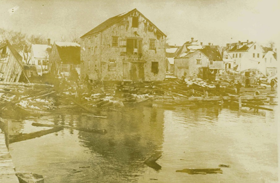
Just like how the natural landscape allowed for the creation of a prosperous fishing village, nature led to its decline. On November 26, 1898, the Portland Gale, named for one of the ships it destroyed, hit the northeast Unites States.8 The gale destroyed most of Provincetown’s fishing wharves, which were then considered useless and never restored. This storm, paired with the discovery of petroleum oil to replace whale oil,4 set in motion the imminent decline of the fishing industry: in the 1860s, there was almost $2,000,000 invested in the fishing and whaling industries in Provincetown, but by 1902, that number had declined to a mere $271,000.9. This situation was mirrored in Nantucket and its whaling industry, which Dona Brown claims was subject to decline due to its “heavy reliance on a single industry.”10 As Provincetown’s ocean-based industries declined, infrastructural improvements that overcame geographical barriers allowed for the emergence of a new industry: tourism.
During the late 1800s, industrialization and improvements to Provincetown’s infrastructure allowed for easier access to the town, which sparked the influx of artists and tourists in the early 1900s. We can start by examining what is now a public parking lot near the center of town.
While at first the location looks insignificant, it gains importance with some historical insight: this was the location of Provincetown’s train station up until its decommission in the 1960s. The layout of the parking lot follows the path of the old train track, which extends out onto Harry Kemp Way. This becomes clear when comparing images from when the station was active to today.
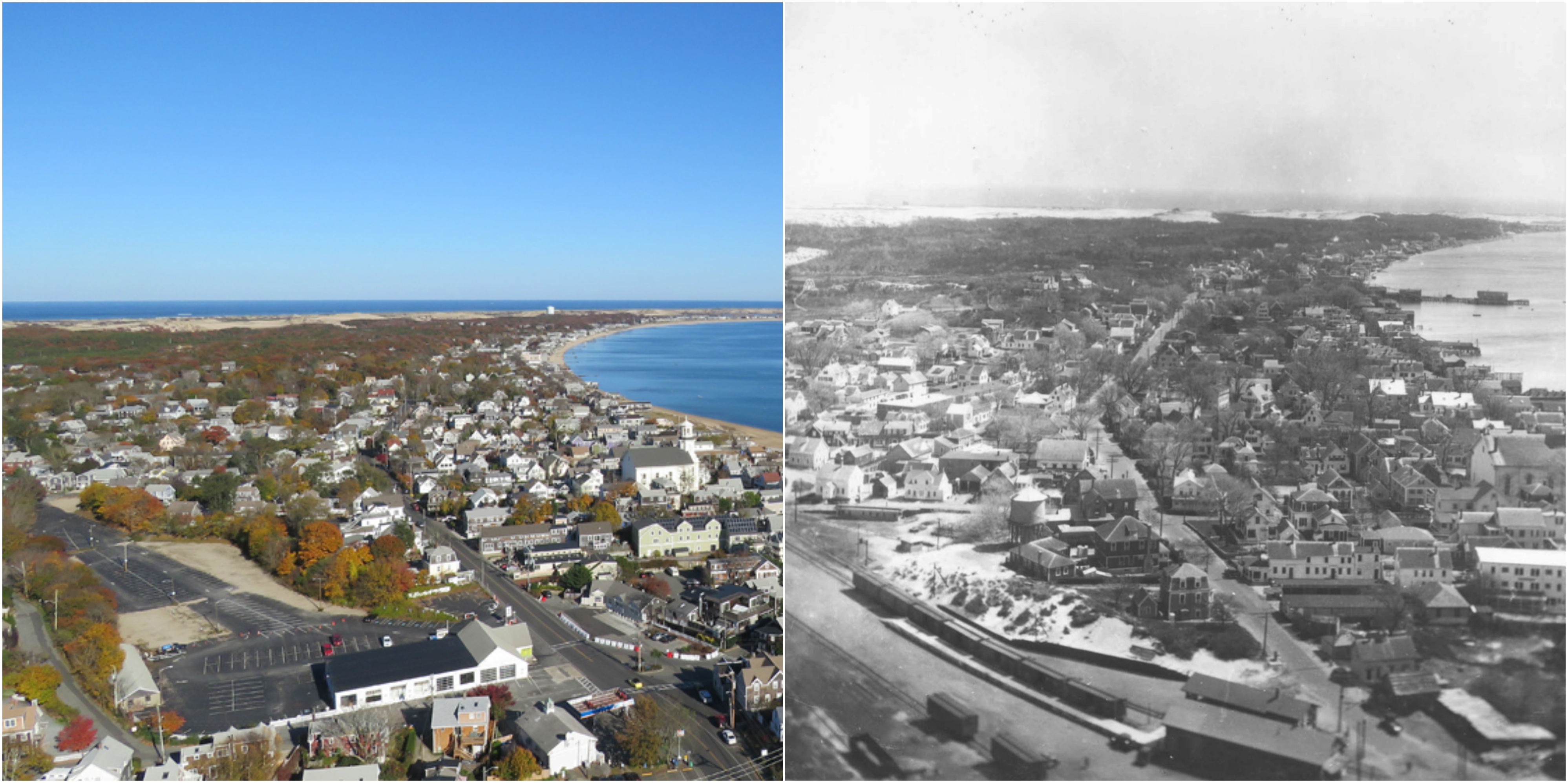
This train track, an extension of the Old Colony Railroad, was built across the now-diked East Harbor in 1873.11 A newspaper article published by the Boston Daily Globe in 1873 documents the events of the railroad’s opening, including where distinguished guests got on the train, the “mammoth tent” and ball at the end of the journey, and the remarks of various speakers. Governor Straw of New Hampshire spoke to the isolation of Provincetown, saying that “the people of the Cape had a wonderful proclivity for travel, and if such had not been the case no one would ever have known that there was such a place.”11 Prior to the construction of the rail, only those inclined to travel would have made the journey to Provincetown. In the words of Karen Krahulik, the railroad became “Provincetown’s most expedient link to the ‘outside world.’”12 Now that the railroad overcame the geographical barriers isolating it from the rest of the world, Provincetown would become more prominent in the region, attracting visitors from all over the country. The development of the railroad at this time was imperative to the evolution of Provincetown into a tourist destination: the timing was just right so that the development of the railroad coincided with the downturn of the fishing and whaling industries, allowing for tourism to immediately take their place as the town’s primary industry.
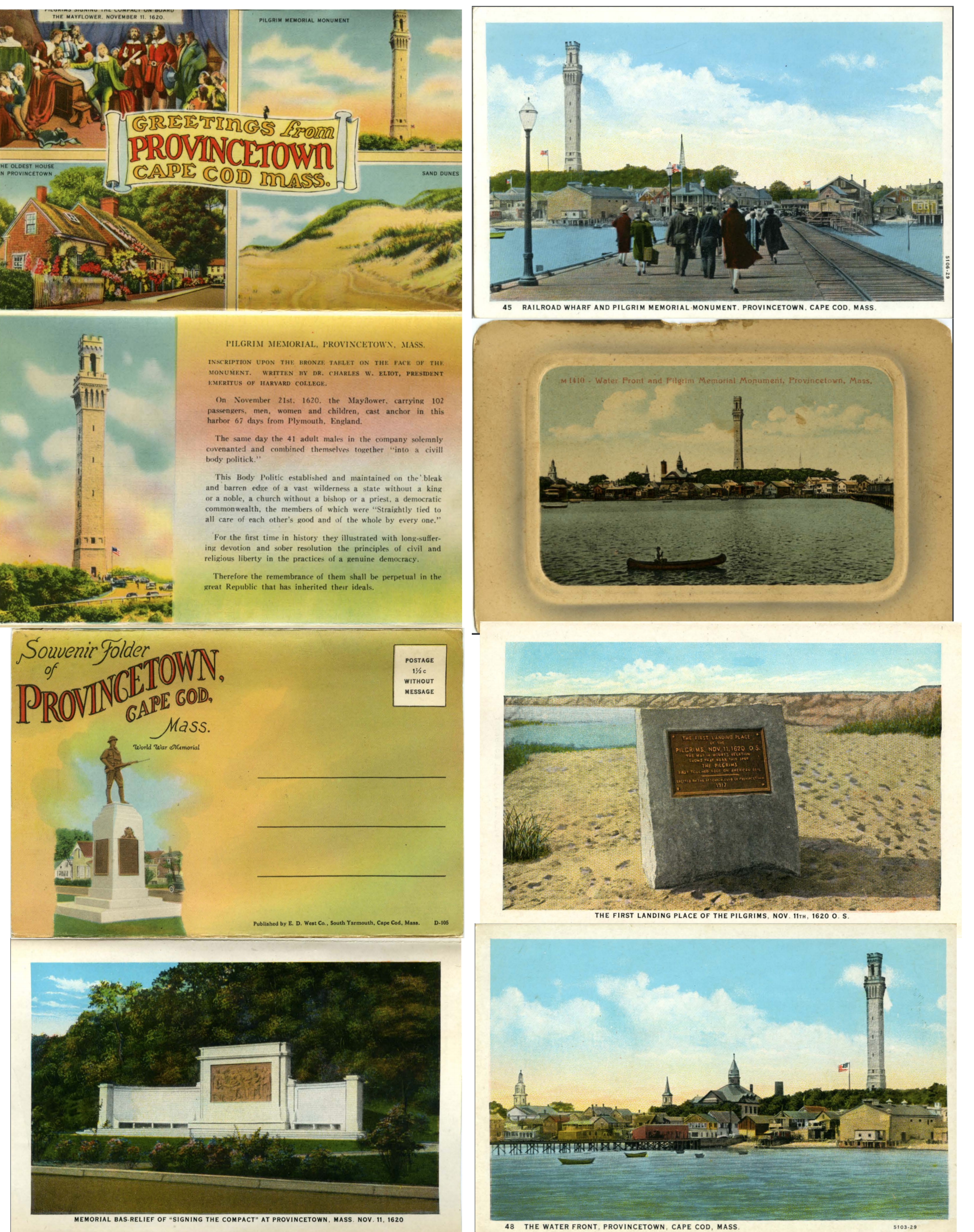
Once the Old Colony Railroad was an established form of transportation for reaching Provincetown, urban residents began to travel there as a means of escape from the filth and corruption of the city.12 This concept became popular throughout New England in the late 1800s, as outsiders looked to rural living as a “resource for the health and well-being of urbanites like themselves.”13 However, this was not the main factor contributing to the growth of Provincetown’s tourism. Provincetown’s tourism boom coincided with another vacationing trend: touring. This practice involved visiting historically significant locations as a form of personal enrichment.14 Fortunately, Provincetown had a history that it could profit off of: its colonial significance as being the landing site for the Pilgrims.
On August 20th, 1907, the cornerstone of the Pilgrim Monument was laid, commemorating the landing of the Pilgrims. A 1932 article from the Provincetown Advocate accurately articulates the draw of the monument’s historical significance on tourists: “It is not only because the monument is erected here and a landmark that it draws its visitors. It is because it holds the memory of the Pilgrim forefathers who stepped onto American soil after anchoring in this harbor.”15 By connecting back to its colonial roots, Provincetown was able to attract tourists seeking an escape to the (seemingly) simpler times of the past.
Provincetown was able to use its distinct historical narrative to attract visitors seeking a colonial experience. Other New England towns took part in this colonialization earlier than Provincetown, utilizing movements such as Colonial Revivalism architecture in order to create an image for the town that brought on sentiments of nostalgia.16 While Provincetown did not necessarily reconstruct itself to the extent that other New England towns did, it highlighted its Yankee history enough to attract visitors seeking a liberating colonial experience.
Provincetown also attracted a different kind of visitor from the middle and upper class tourists looking for a historical experience: artists. While many New England towns attracted writers such as Robert Frost, Provincetown primarily attracted painters looking to capture the serene coastal landscape. The prevalence of the artistic began most distinctly in 1899, when Charles Webster Hawthorne founded the Cape Cod School of Art.17 Since then, Provincetown’s artistic community has grown, and in 1916 The Boston Globe announced in a headline: “Biggest Art Colony in the World at Provincetown.”18 Today, many of the high-end galleries reside in the East End of town. This is where Hawthorne taught painting, and many other artists decided to take up residence.19
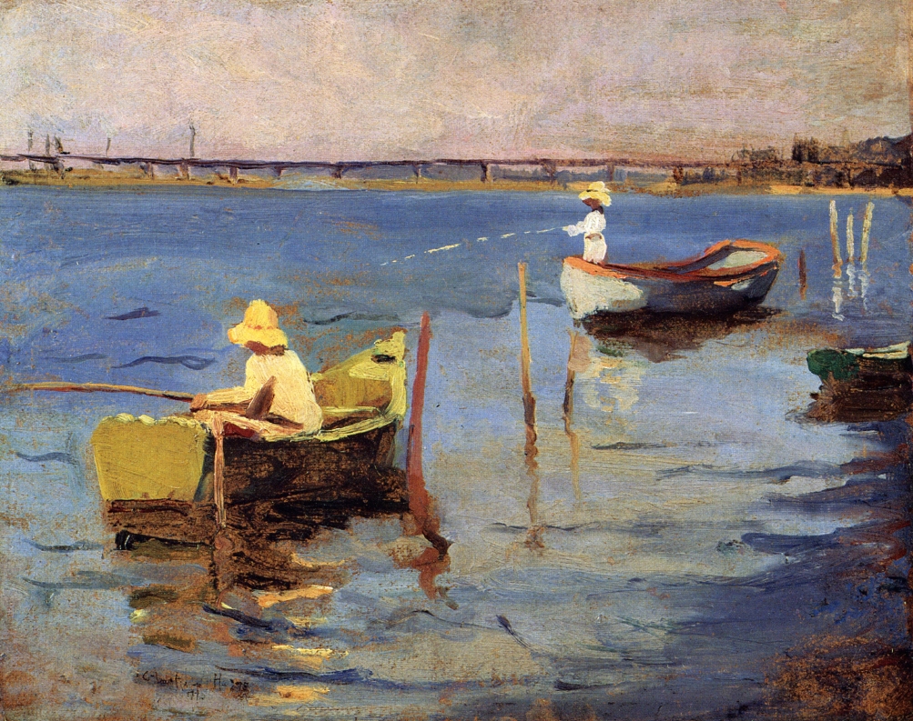
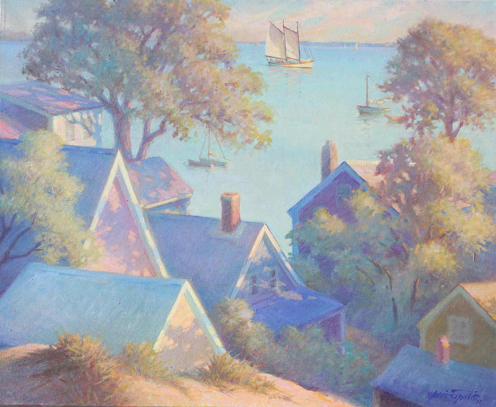
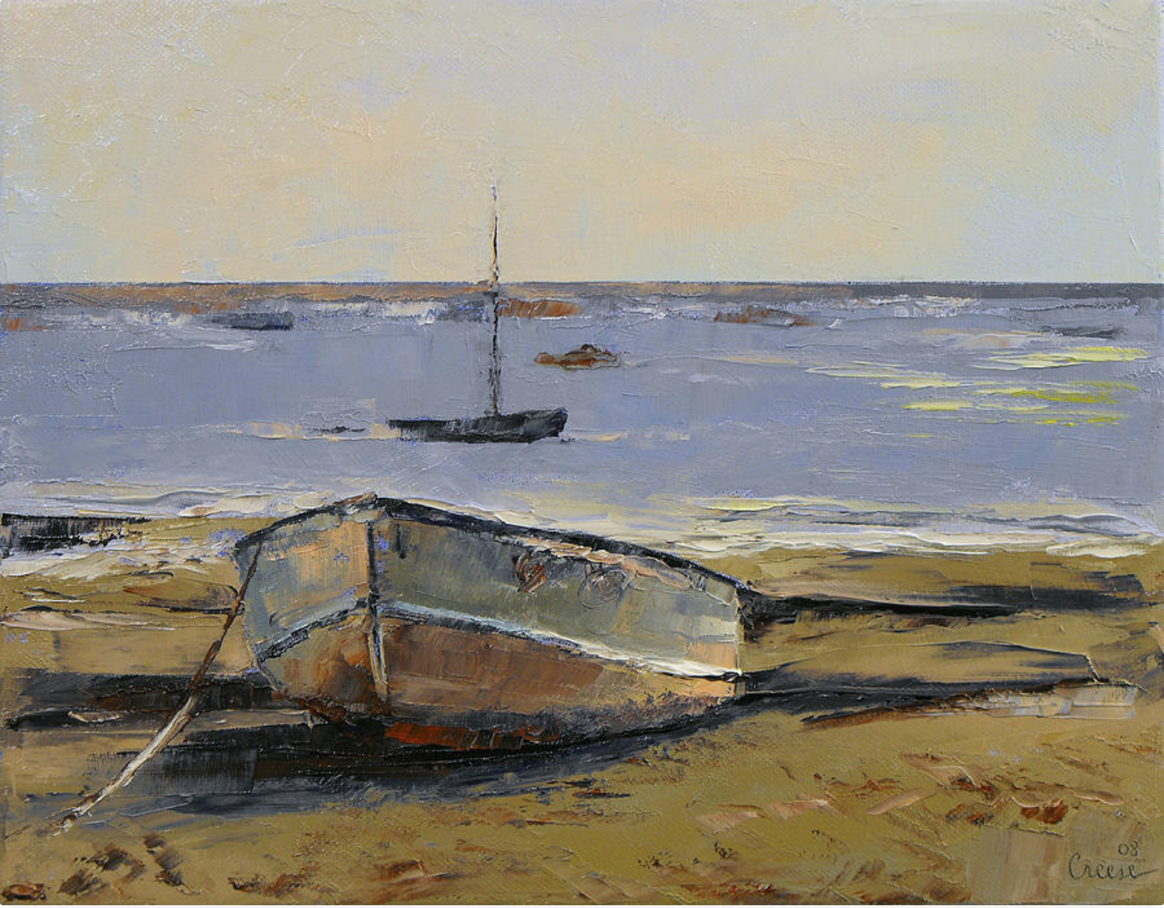
As seen in the images above, much of the artwork created in Provincetown are paintings of landscapes. The natural landscape of the town seemingly lends itself to the creation of expressive art. As Michael Cunningham puts it in his book Land’s End, “The light in Provincetown rivals that of Paris or Venice… [i]ts light is aquatic; it falls not only down from the sky but up again from the water…as if between two immense platters of mirror.”20 There exists an array of different landscapes that artists can choose to recreate, from the ocean to quaint houses to the bustling town center. Because of this variety paired with the artistic freedom of artists, painters are able to fabricate their own version of town in each work of art they create. Those who view the artwork are then exposed to the often-romanticized perspective of Provincetown. In that sense, the artwork created in Provincetown acts as a form of advertisement for the town, drawing in people who want to experience the emotions evoked by the artwork. Even if people have never been to Provincetown, they still have a sense of Provincetown’s identity as seen through the artwork.
Provincetown is arguably best known for being a town in which people can freely express their sexual identity. According to census data from 2010, Provincetown has 163 same-sex couples for every 1000, causing it to have the highest concentration of same-sex couples in the country.1 But how did this happen? As it turns out, Provincetown’s geography played a large role in this - Provincetown’s geographical isolation offered “a measure of anonymity, protection, and romance” that members of the LGBT community found liberating.21 Additionally, Provincetown’s reputation as being an art colony contributed towards the attraction of gays and lesbians. While Provincetown began as a center for formal art forms, an entertainment culture soon developed to complement it. This “artsy” climate drew in increasing numbers of LGBT tourists in the 1900s, until Provincetown became known for liberal attitudes towards sexual identity. 22 Today, this gay entertainment culture is evident in the shows and nightclubs that are present in the West End of town. As you walk down Commercial Street during the height of the tourist season, no one bats an eye at the people dressed in drag or the countless same-sex couples. Thanks to the way that Provincetown’s physical and cultural landscapes shaped its development, there now exists a place where people of any sexual identity can feel overwhelmingly welcomed.
Ultimately, Provincetown’s identity as an artistic, gay seaside resort town originally stemmed from its physical geography. Its isolation and proximity to the ocean allowed for it to initially become a successful fishing town, and infrastructural improvements were used to overcome the natural barriers that separated Provincetown from the “real world” just when its marine industries began to decline. This allowed for the immediate rise of the tourism industry, which primarily drew in people looking for a historical experience and artists. Both the isolation of Provincetown away from social centers like cities and the presence of a prevalent artistic community allowed for the creation of a distinct LGBT community, distinguishing Provincetown from any other location in New England.
Cover image credit: Wikimedia Commons
Sydney Gillman is a student at Dartmouth College
Megan Gibson, “According to Census Data, This Is America’s Gayest City,” Time. August 25, 2011. Accessed November 12, 2017. http://newsfeed.time.com/2011/08/25/according-to-census-data-this-is-americas-gayest-city/. ↩ ↩
Karen Christel Krahulik, Provincetown: From Pilgrim Landing to Gay Resort (New York: New York University Press, 2005) 4. ↩
Nancy W. Paine-Smith, The Provincetown Book (Brockton: Tolman Print, 1922) 45. ↩
Mary Bauer, “During Provincetown’s Boom Fishing Years, Wharves Lined the Waterfront,” The Advocate Spring Real Estate Guide, April 12, 1979. ↩
“Scrapbooks of Althea Boxell, Book 5, Page 2,” The Provincetown History Preservation Project. ↩
Krahulik, Provincetown, 5. ↩
“One Provincetown Man,” Boston Daily Globe, Jan 03, 1899, https://search-proquest-com.dartmouth.idm.oclc.org/docview/499029056?accountid=10422. ↩
“Nearly $2,000,000 for Fish,” Boston Daily Globe, Aug 24, 1902, https://search-proquest-com.dartmouth.idm.oclc.org/docview/499716972?accountid=10422. ↩
Dona Brown, “Manufactured for the Trade,” in Inventing New England: Regional Tourism in the Nineteenth Century, (Washington: The Smithsonian Press, 1995) 110. ↩
“Railroad Extension,” Boston Daily Globe, Jul 23, 1873, https://search-proquest-com.dartmouth.idm.oclc.org/docview/491867559?accountid=10422. ↩ ↩
Brown, “Manufactured for the Trade,” 153-154. ↩
Krahulik, Provincetown, 21. ↩
“Pilgrim Memorial Monument,” The Provincetown Advocate, Aug 18, 1932. ↩
Scott R. Roper, “Wrought in the Spirit of Our Ancestors” in A Landscape History of New England, ed. Blake Harrison and Richard W. Judd (Cambridge: MIT Press, 2011), 305-320. ↩
Krahulik, Provincetown, 69. ↩
“Biggest Art Colony in the World at Provincetown,” The Boston Globe, Aug 27, 1916. ↩
Michael Cunningham, Land’s End: A Walk Through Provincetown, (New York:Crown Journeys, 2002) 137-153. ↩
Cunningham, Land’s End, 138. ↩
Krahulik, Provincetown, 12. ↩
Krahulik, Provincetown, 135. ↩